

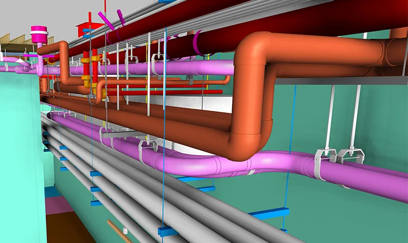

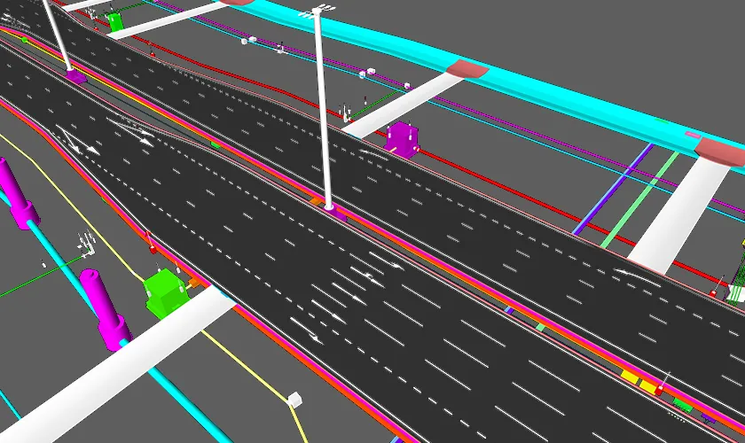

Endeion provides BIM for infrastructure and civil services for engineering consultants, contractors, developers, utility teams, and public-sector project stakeholders. Our team develops coordinated digital models and documentation from approved drawings, survey information, point cloud data, specifications, and project standards. The resulting information can support planning, multidisciplinary coordination, quantity review, construction documentation, as-built records, and asset handover.
Unlike building-only BIM workflows, civil infrastructure BIM services must account for large project areas, real-world coordinates, terrain, alignments, buried networks, drainage systems, structural interfaces, and phased construction. Endeion organizes these inputs within practical BIM and civil modeling workflows so project teams can review complex information in a clearer, more connected environment.
Our BIM services are developed according to the agreed scope, required Level of Development, client standards, software environment, and intended use. Endeion provides modeling and documentation support based on approved engineering information. Design responsibility, regulatory approval, and engineering certification remain with the appropriately appointed project professionals unless separately defined by contract.
Civil BIM Support for Coordinated Infrastructure Delivery
Civil BIM brings geometric, spatial, and project information together, so teams can review infrastructure systems in context rather than relying only on disconnected plans and spreadsheets. Depending on the project, a civil BIM environment may combine terrain surfaces, roads, drainage, utilities, structures, buildings, equipment, access zones, and existing conditions.
This connected approach can help project teams identify spatial conflicts earlier, understand interfaces between disciplines, prepare clearer drawings, and maintain a more consistent record of design changes. It is especially useful where horizontal and vertical infrastructure must be coordinated across large sites or where underground conditions affect construction sequencing.
Our BIM Services for Infrastructure and Civil Projects
Endeion provides BIM services for infrastructure across design development, preconstruction, coordination, construction documentation, and as-built stages. The exact combination of models, drawings, schedules, and data outputs is established during project scoping.
Transportation and Roadway BIM Modeling
For roadway and transportation projects, Endeion can develop model-based information for roads, highways, intersections, ramps, sidewalks, parking areas, rail-adjacent infrastructure, and related civil components. Modeling may include alignments, profiles, corridors, surfaces, grading, pavement zones, drainage interfaces, retaining elements, and utility crossings when these are included in the approved source of information.
The model can support visual review, design coordination, construction drawing production, quantity extraction, and communication among civil, structural, utility, and construction teams. Endeion does not replace transportation engineering analysis or traffic design. Our role is to translate approved project information into coordinated digital deliverables.
Land and Site Development Modeling
Our civil BIM support can cover site-development information such as existing and proposed terrain, grading zones, access roads, parking layouts, retaining walls, site structures, drainage paths, utility corridors, and landscape-related interfaces. These models help teams review how proposed site elements relate to topography, buildings, structures, and below-grade systems.
For phased developments, models can also be organized by area, package, or construction stage. This provides a clearer basis for coordination and documentation while allowing project teams to control how much information is developed at each milestone.
BIM for Underground & Overhead Utilities
Endeion supports BIM for underground & overhead utilities using client-provided survey data, design drawings, utility records, specifications, and coordination requirements. Models may represent water lines, sanitary sewer, storm drainage, gas systems, process piping, electrical duct banks, telecom routes, manholes, chambers, poles, transmission elements, and project-specific utility structures.
BIM underground services help teams review depth, elevation, slope, crossings, clearances, structure interfaces, and access requirements within a coordinated environment. Each BIM underground service scope should identify the required systems, reliability of the source data, expected accuracy, and whether the model represents design intent, verified existing conditions, or as-built information.
Water, Wastewater, Drainage, and Plant Modeling
Civil BIM models can support water distribution, sanitary sewers, stormwater, drainage, pumping, treatment, and plant-related projects. Depending on the available inputs, Endeion can model networks, structures, equipment zones, piping, channels, tanks, chambers, access areas, and interfaces with buildings or civil structures.
For treatment of plants and utility facilities, coordination may extend across civil, structural, architectural, mechanical, electrical, plumbing, and process systems. The purpose is to improve spatial understanding and documentation, not to perform hydraulic, process, or environmental engineering calculations unless those services are separately provided by responsible consultants.
Bridge, Tunnel, Retaining Wall, and Civil Structure Modeling
Where suitable design information is available, Endeion can develop BIM models and documentation for bridges, underpasses, overpasses, tunnel components, portals, retaining walls, barriers, culverts, foundations, access structures, and other civil assets. These models may support coordination, visualization, drawing production, construction planning, quantity review, and as-built documentation.
Structural geometry, reinforcement, connections, and detailed components are modeled to the agreed level and based on approved engineering inputs. Structural analysis, load verification, geotechnical evaluation, and final design approval remain outside the BIM production scope unless specifically contracted through qualified professionals.
Scan-to-BIM and As-Built Documentation
For renovation, expansion, rehabilitation, and existing-infrastructure projects, Endeion can convert client-provided point cloud data, surveys, markups, redlines, and record drawings into BIM models and as-built documentation. Outputs may include coordinated models, plans, profiles, elevations, sections, utility layouts, and asset information based on the agreed project requirements.
The accuracy of an as-built model depends on the quality, coverage, registration, and reliability of the source of information. Endeion confirms modeling assumptions and exclusions during scoping, so users understand what has been directly supported by the available data.
How Civil Infrastructure BIM Services Support Project Teams
Multidiscipline Coordination
Infrastructure BIM services allow civil models to be reviewed alongside architectural, structural, MEP, process, landscape, and utility information. This is valuable at building-to-site connections, road crossings, bridge approaches, plant areas, shafts, utility corridors, and other locations where multiple systems compete for space.
Clash Detection and Interface Review
Federated models can be checked for physical intersections, clearance concerns, elevation conflicts, access limitations, and inconsistent interfaces. Examples include underground lines crossing foundations, drainage structures conflicting with roads, utility routes intersecting bridge elements, or plant piping competing with structural and MEP systems. Identified issues are documented for review and resolution by the responsible project stakeholders.
Construction Documentation
Model-based plans, profiles, sections, details, schedules, and civil shop drawings can be prepared when included in the scope. These deliverables are developed from coordinated information and formatted according to client templates, drawing standards, and project submission requirements.
Quantity and Material Review
Where models contain the required geometry and classifications, quantities may be extracted for earthwork, pavement, concrete, drainage, utilities, structural components, and other measurable elements. Quantity outputs should be reviewed against project measurement rules, design status, and exclusions before they are used for bidding, procurement, or cost planning.
Lifecycle and Handover Information
Civil BIM can also support as-built records, asset registers, COBie-related information, and facility-management data when these deliverables are defined early. Data fields, naming conventions, classifications, and software requirements should be established before handover information is populated.
Our Civil and Infrastructure BIM Workflow
Our BIM infrastructure services are organized around clear inputs, defined uses, controlled reviews, and agreed deliverables. The workflow can be adapted for project-based support, individual civil packages, or multidisciplinary infrastructure programs.
1. Project Scope and Input Review
We review the available civil, structural, utility, architectural, MEP, survey, point cloud, GIS, specification, and BIM documents. The team confirms model uses, required disciplines, coordinate systems, units, LOD or information requirements, software formats, drawing standards, milestones, and exclusions.
2. Coordinate and Model Setup
Levels, grids, survey coordinates, shared coordinates, reference points, surfaces, alignments, work areas, file naming, and model segmentation are established according to the agreed project standards. Correct setup is essential for reliable federation and spatial review.
3. Civil BIM Model Development
Endeion develops the included site, transportation, utility, drainage, structural, or facility components from approved source information. Models are organized to support the intended use without adding unnecessary detail that does not benefit from coordination or delivery.
4. Model Federation and Coordination
Discipline models are combined in a coordination environment, so interfaces can be reviewed. The team checks alignment, geometry, levels, major clearances, and project-specific coordination rules using tools appropriate to the scope.
5. Issue Documentation and Updates
Coordination issues are recorded using views, screenshots, reports, comments, or issue-management formats agreed with the client. Model revisions are incorporated after instructions, approvals, or updated design information are received.
6. Drawing and Data Production
Required plans, profiles, sections, schedules, quantity outputs, shop drawings, as-built sheets, or handover data are prepared from the reviewed model. Deliverables are checked for consistency with the current project information.
7. Quality Control and Delivery
Before delivery, Endeion checks file organization, coordinates, visible geometry, required information, drawing references, naming, and output formats. Final files are issued according to the agreed milestone and revision status.
Typical Civil BIM Deliverables
Depending on the approved scope, Endeion’s BIM for civil infrastructure projects may include:
- Civil 3D, Revit, Tekla, Navisworks, or other agreed model files
- Existing and proposed terrain or surface models
- Road, corridor, alignment, grading, and site models
- Underground and overhead utility models
- Stormwater, sanitary, water, drainage, and related civil system models
- Bridge, tunnel, retaining wall, culvert, and civil structure models
- Federated coordination models and issue reports
- Plans, profiles, sections, elevations, and project-specific details
- Civil construction drawings or shop drawings where included
- Scan-to-BIM models and as-built documentation
- Quantity schedules or material data based on model content
- FM, asset, or COBie-related data where defined by the client
Not every project requires every deliverable. The delivery package should be selected according to the project phase, contractual BIM requirements, available information, and intended downstream use.
BIM Infrastructure Project Types We Support
Endeion’s infrastructure BIM services can be configured for a range of civil and public works projects. Relevant scope depends on available inputs, client requirements, and the role assigned to Endeion.
Roads, Highways, and Transportation
Road corridors, highway improvements, intersections, ramps, sidewalks, parking facilities, rail interfaces, metro-related civil works, drainage, signage zones, and utility crossings.
Land, Site, and Development Infrastructure
Site grading, terrain, access, parking, retaining systems, civil structures, landscaping interfaces, stormwater features, and utility networks for commercial, residential, industrial, institutional, and mixed-use developments.
Water, Wastewater, and Utility Facilities
Water distribution, sanitary sewer, stormwater, pumping, treatment, process support, utility chambers, plant piping interfaces, and related civil structures.
Bridges, Tunnels, and Public Infrastructure
Bridge components, underpasses, overpasses, retaining walls, culverts, tunnel portals and support spaces, civic facilities, parks, stadium-related infrastructure, and other project-specific public assets.
Industrial, Marine, and Specialized Civil Projects
Industrial sites, manufacturing facilities, logistics developments, large utility corridors, dock or harbor-related components, and specialized infrastructure where digital modeling supports coordination and documentation.
Why Choose Endeion for Civil BIM Services?
Civil and Multidiscipline BIM Capability
Endeion works across civil, structural, architectural, MEP, utility, and construction-documentation workflows. This allows the team to support interfaces that cannot be resolved effectively within a single-discipline model.
Software-Aligned Delivery
The team works with platforms identified on Endeion’s current service page, including Civil 3D, Revit, Navisworks, Tekla, and AutoCAD Plant 3D. Software selection and exchange formats are confirmed according to the project workflow and client requirements.
Scope-Based Modeling
Models are developed for a defined project use and level of information. This helps avoid both under-modeling that cannot support coordination and over-modeling that adds cost without improving the intended deliverable.
Structured Quality Control
Endeion reviews model setup, coordinates, geometry, naming, required data, drawing consistency, and output formats before milestone delivery. Coordination findings are documented for project-team review instead of being presented as automatic engineering decisions.
Flexible Production Support
Clients can use Endeion for a defined project package, specific discipline, coordination support, drawing production, as-built updates, or additional civil BIM capacity. This allows internal teams to maintain project control while extending production resources when needed.
FAQs About BIM for Infrastructure and Civil Services
What is civil BIM?
Civil BIM is the use of coordinated digital models and structured project information for civil works such as roads, sites, utilities, drainage, bridges, tunnels, and public infrastructure. It helps teams visualize conditions, coordinate disciplines, prepare documentation, and maintain more consistent information across project stages.
What is the difference between building BIM and BIM for civil infrastructure?
Building BIM typically focuses on vertical assets and their architectural, structural, and MEP systems. BIM for civil infrastructure must also manage terrain, survey coordinates, alignments, long corridors, grading, drainage, underground networks, and interfaces spread across large geographic areas. Many projects require both workflows to be coordinated.
What information does Endeion need to begin an infrastructure BIM project?
Typical inputs include survey files, CAD drawings, Civil 3D files, GIS information, point clouds, engineering drawings, specifications, BIM execution requirements, coordinate information, required software formats, project milestones, and a list of expected deliverables. Endeion reviews the files and confirms assumptions before production begins.
Does Endeion provide BIM underground services?
Yes. Endeion can model and coordinate underground utilities such as water, sanitary sewer, storm drainage, gas, electrical duct banks, telecom routes, process lines, chambers, and related structures when suitable design, survey, or record information is available. Accuracy and model status are defined by the source data and agreed scope.
Can civil BIM be used for overhead utilities?
Yes. Overhead utility elements such as poles, lighting, telecom infrastructure, transmission components, and associated routes can be included when required. The model can support spatial coordination and documentation, while engineering clearance and code decisions remain with the responsible project professionals.
What software does Endeion use for civil infrastructure BIM services?
Endeion’s current website identifies Civil 3D, Revit, Navisworks, Tekla, and AutoCAD Plant 3D among its infrastructure BIM tools. The actual software combination depends on the disciplines involved, available source files, coordination requirements, and required deliverable formats.
Can Endeion create as-built civil BIM models?
Endeion can prepare as-built models and drawings from client-provided point clouds, surveys, field markups, redlines, record drawings, and verified project information. The deliverable should clearly identify the source, expected accuracy, included assets, and any areas that could not be confirmed.
Does Endeion perform civil engineering design?
This service page describes BIM modeling, coordination, documentation, and data support. Endeion develops deliverables from approved engineering information and project instructions. Engineering calculations, design approval, regulatory certification, and engineer-of-record responsibilities are not assumed unless they are specifically included through appropriately qualified professionals.
How can infrastructure BIM services improve coordination?
A federated model allows road, terrain, drainage, utility, structural, architectural, and MEP information to be reviewed together. This can reveal spatial conflicts, inconsistent elevations, missing interfaces, access concerns, and drawing discrepancies earlier, giving the responsible project team more time to evaluate and resolve them.
How do I get started with Endeion?
Send Endeion the available project files, required disciplines, project location, schedule, BIM standards, intended model use, and expected outputs. The team can review the information and propose a scope for modeling, coordination, drawings, as-built documentation, or other agreed BIM for infrastructure services.
Areas We Serve
- Alabama
- Albany
- Arizona
- Atlanta
- Augusta
- Bakersfield
- Boston
- Brownsville
- Buffalo
- California
- Charlotte
- Chicago
- Cleveland
- Colorado
- Columbia
- Columbus
- Concord
- Connecticut
- Dallas
- Florida
- Georgia
- Hawaii
- Houston
- Illinois
- Indiana
- Kansas
- Kentucky
- Los Angeles
- Louisiana
- Maine
- Maryland
- Massachusetts
- Mississippi
- Missouri
- Montana
- Nebraska
- Nevada
- New Hampshire
- New Mexico
- New York
- North Carolina
- North Dakota
- Ohio
- Oklahoma
- Oregon
- Orlando
- Pennsylvania
- Portland
- Rhode Island
- Seattle
- South Carolina
- Texas
- Vermont
- Virginia
- Washington
- West Virginia
- Wisconsin